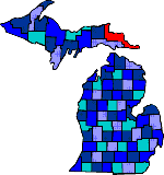

| Size: 1590 Square Miles |
| Elevation: 600-1000 Feet |
| Physiography: Lake-border-plains, rolling plains |
| Growing Season: 120-140 days |
| Annual Precipitation: 30-33 inches |
| Average Snowfall: 90-110 inches |
| Forest Type: Maple-Beech-Hemlock, Aspen-Birch, Spruce-Fir |
| Fall Colors: Late September |
| In 1641 French missionaries named Sault Ste Marie. Sault Ste Marie was a British fur trader area until the War of 1812. Work on the Soo Locks began in the 1850's and the first set of the locks was completed in 1855. The locks increased Great Lakes shipping. The largest dolomite limestone quarry is located on Drummond Island. |
| Barbeau (49710) | Brimley (49715) | Dafter (49724) |
| De Tour Village (49725) | Drummond Island (49726) | Eckeman (49728) |
| Fibre (49780) | Goetzville (49736) | Hulbert (49748) |
| Kincheloe (49788) | Kinross (49752) | Paradise (49768) |
| Pickford (49774) | Raco (49715) | Rudyard (49780) |
| Sault Ste Marie (49783) | Stalwart (49736) | Strongs (49790) |
| Trout Lake (49793) |
|
Copyright | 2021 | michiganweb.com
|