| Size: 350 Square Miles |
| Elevation: 600-1000 Feet |
| Physiography: Hill Lands |
| Growing Season: 130-150 days |
| Annual Precipitation: 29-31 inches |
| Average Snowfall: 80-100 inches |
| Forest Type: Spruce-Fir, Maple-Beech-Birch-Hemlock |
| Fall Colors: Late September - Early October |
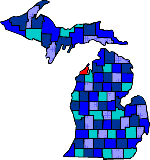
| Known as the "little finger" of the Michigan mitten. Leelanau was named after a Chippewa girl meaning "delight of life". Between the Manitou Island and the mainland is the Manitou Passage which is used by vessels on Lake Michigan. After a lighthouse was built on South Manitou Island missionaries started Indian Missions. By the mid 1870's there were many loggers, fruit farmers, and summer vacationers. Leelanau's white beaches attracted vacationers. Leelanau is Michigan's leading cherry producer. The Sleeping Bear National Shoreline is part of this county. |
| Ahgosatown | Armstrong | Bingham |
| Bodus | Burdickville | Cedar (49621) |
| Denoyer | Dewings | Eagletown |
| Empire (49630) | Fouch | Glen Arbor (49636) |
| Glen Haven | Greilickville | Heimforth |
| Isadore | Jacktown | Kasson |
| Keswick | Lake Leelanau (49653) | Leland (49654) |
| Maple City (49664) | North Manitou | Northport (49670) |
| Omena (49674) | Onumeneseville | Osborn |
| Peshawbestown | Port Oneida | Schomberg |
| Seeburger | Solon | Suttons Bay (49682) |
| Waukazoo |
|
Copyright | 2021 | michiganweb.com
|