| Size: 1841 Square Miles |
| Elevation: 600-1800 Feet |
| Physiography: Hill-lands |
| Growing Season: 80-120 days |
| Annual Precipitation: 31-33 inches |
| Average Snowfall: 90-140 inches |
| Forest Type: Maple-Hemlock, Aspen-Birch, Pine-Oak, Spruce-Fir |
| Fall Colors: Late September |
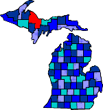
| Marquette County was named in honor of Father Marquette and is Michigan's largest county. The Chippewa and Ojibway Indians lived in the mouth of the Chocolay and Carp Rivers. Various men explored the area in the 1800's. In 1845 the Jackson Mining Company was founded which started iron ore mining in Marquette County. While the Civil War was going on the county grew due to the demand for iron to help the northern war effort. Northern Michigan University was established in 1899 in Marquette. Iron ore remains the largest industry in the county. |
| Arnold (49819) | Beaver Grove (49855) | Big Bay (49808) |
| Champion (49814) | Cornell (49819) | Gwinn (49841) |
| Harvey | Ishpeming (49849) | K I Sawyer AFB (49843 |
| Little Lake (49833) | Marquette (49855) | Michigamme (49861) |
| National Mine (49865) | Negaunee (49866) | Northland (49869) |
| Palmer (49871) | Princeton (49841) | Republic (49879) |
| Skandia (49885) |
|
Copyright | 2021 | michiganweb.com
|