Michiganweb - Michigan Info Net

MASON COUNTY MICHIGAN


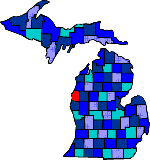
Mason county map

Size: 493 Square Miles
Elevation: 600-1000 Feet
Physiography: Rolling plains, lake border plains
Growing Season: 160-180 days
Annual Precipitation: 30-34 inches
Average Snowfall: 60-90 inches
Forest Type: Maple-Beech-Birch-Hemlock, Oak-Hickory
Fall Colors: Late September - Early October

Named after Michigan's first governor, Steven Mason. In the mid 1600�s French missionaries, including Father Pere Marquette, visited the Ottawa Indians here and Marquette�s Memorial on the south side of the channel marks his death in 1675. In 1847 Burr Caswell settled in the county at the mouth of the Pere Marquette River. Because of all the Pine trees lumbering became a major industry. Car ferries began in 1897 and today there are still still operating year round between Ludington and Manitawoc, Wisconsin. The Pere Marquette River, a major attraction here which empties into Lake Michigan at Ludington.

Mason County Area

Amber Bachelor Carr
Custer (49405) Fern Fountain (49410)
Freesoil (49411) Hamlin Ludington (49431)
Millerton Scottville (49454) Tallman
Victory Walhalla (49458) Weimer
Wiley blank blank


Main Page Disclaimer

Copyright | 2021 | michiganweb.com